Climatically Safe Pathways
Between June and July, Barcelona hosted the UIA World Congress of Architects. I was only able to attend the first day, dedicated to two central themes: Becoming More Than Human and Becoming Circular.
I was sitting in a room air-conditioned to 21 degrees. Outside, the year’s first heatwave was reaching its peak; inside, at one point, I had to put on a sweater. As the discussion turned to overcoming anthropocentrism — thinking not only for humans but also recognizing plants, animals (and why not artifacts too) as political subjects with whom to establish mutually beneficial relationships of collaboration — I found myself in what felt like the most anthropocentric place possible: a box isolated from the world, which to exist consumes the energy the world outside is already paying for, a reflection of a way of practicing architecture — often excellent architecture — that makes isolation, both structural and functional, one of its guiding principles.
The paradox suggested a question I find more useful than the simple contrast itself: if part of the interspecies collaboration being discussed also consists of adapting rather than dominating , what does it mean to apply this idea to our own bodies, to our daily habits? I don’t mean a bucolic return to the rhythms of the earth, but a concrete strategy for continuing to live — going to work, buying groceries, sleeping — in a surrounding environment that we ourselves have made more hostile, and that we cannot update at the speed that would be needed.
Barcelona already has a partial answer: its network of climate shelters. It’s a serious solution to a real problem, but the name itself reveals its limit: a shelter is a place where you stop and wait for the problem to pass, an emergency pause within the normal flow of life. The kind of adaptation I mean is something else: it assumes that daily life can keep moving even under difficult conditions — conditions that, everything suggests, are becoming the new normal.
From here comes the idea of a network of climatically safe pathways: not static points to take refuge in, but alternative routes that reward not only speed but the climatic wellbeing of the journey — a variable depending on time of day, season, and the person walking it.
So I looked to see whether anyone had already developed something like this. To my great surprise, I discovered that AMB is developing a tool that does exactly this: it suggests the best route by interpolating walkability data, coolness, and other environmental and topographic parameters. At the moment and it’s already usable in an experimental phase here.
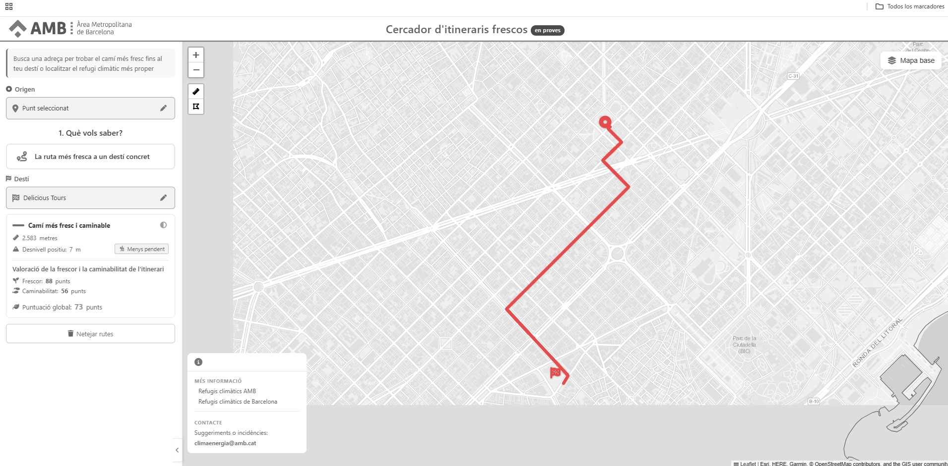
You enter a starting point and a destination, and the tool returns the coolest route, along with supporting data — elevation gain, distance, a coolness score, a walkability score, and an overall score.
It’s a powerful tool, and exactly what seemed to be missing: not just the fastest route, but one built around wellbeing as a parameter.
For a moment I seriously asked myself: what use is my own device, the WKd, if something this much more powerful and scalable already exists?
I tried getting it to suggest my route from home to the studio, and the path it proposes is partly different from the one I usually take — the one published here — especially at the start and the end. What stands out most is that it sends me on a long detour, seemingly counterintuitive at first, to go around Glòries park instead of crossing through it.
I don’t yet know whether this is a flaw or a choice justified by parameters I’m not immediately grasping — and that’s exactly the question I want to test by walking it, verifying it with the WKd, to understand whether the wellbeing gained is worth the cost of the detour.
This season of continuous heatwaves is obviously a prime opportunity to test these routes: to see whether the experience of walking them is rewarding, whether — despite the unexpected events every day brings — some routes tolerate the unexpected better than others, or seem to draw quality precisely from making it easier to deal with.
All this without forgetting that, potentially, building a fabric of personal stories — attentive to representing different collectives and making explicit how they live and perceive certain stretches of the city, their own personal portion of the city — becomes an opportunity for an atlas of perceived the city during heatwaves.
AMB’s tool thus becomes an infrastructure that can suggest routes, on top of which walkographies can be programmed to find new paths to test during extreme episodes.
What we’d have, then, is an atlas of the perceived city during heatwaves, where personal stories, AMB’s available data, and the data collected by the WKd function as a system that checks and supports itself — in order to eventually suggest new places worth intervening on, new nodes of wellbeing, a new image of the city’s livability, one that shifts with the season and with who is living it.
The next step, then, is concrete: to walk some of the routes AMB has suggested, and to verify with the device — and with the body — whether the route that scores coolest on the data is also the best route to actually live.
To understand at what point the coolest route stops being the best alternative.
To understand whether the sunniest route might become the better choice in winter. Or the safest one, with fewer crossings, less traffic… and, in the future, to organize collective drifts along these routes to arrive at a complex, non-fixed image of them